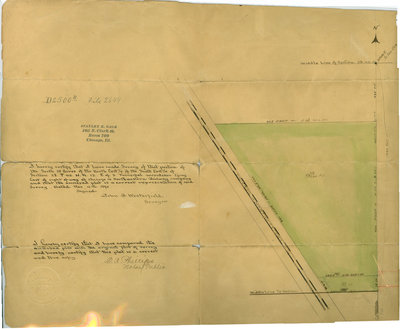
Survey of a subdivision made by John A. Westerfield, surveyor
Description
- Creator
- Westerfield, John A., Surveyor
- Media Type
- Image
- Text
- Item Type
- Maps
- Description
- Hand drawn survey of Wilmette. Green wash color on part of the map.
- Inscriptions
- D2500B File 2649; [stamped] Stanley K. Gage, 105 N. Clark St., Room 709, Chicago, Ill.
[handwritten in ink] I hereby certify that I have made Survey of that portion of the South 25 acres of the North East 1/4 of the South East 1/4 of Section 28 T 42 N.R. 13 E of 3 principal meridian lying East of right of way of Chicago and Northewstern Railway company and that the annexed plat is a correct representation of said survey. Dated Nov. 4th 1890. Signed John G. Westerfield, Surveyor
I hereby certify that I have compared the annexed plat with the original plat of survey and hereby certify that this plat is a correct and true copy. C. A. Phillips, Notary Public.
[embossed seal of C.A. Phillips, Notary, DuPage Co., Illinois] - Date of Publication
- 4 Nov 1890
- Dimensions
-
Width: 19 in
Height: 15 in
- Subject(s)
- Local identifier
- Map 5
- Language of Item
- English
- Geographic Coverage
-
-
Illinois, United States
Latitude: 42.07225 Longitude: -87.72284
-
- Copyright Statement
- Public domain: Copyright has expired according to United States law. No restrictions on use.
- Terms of Use
- Image may be used with credit to Wilmette Public Library
- Contact
- Wilmette Public LibraryEmail:refdesk@wilmettelibrary.info
Website:
Agency street/mail address:1242 Wilmette Avenue
Wilmette, IL
60091-2558
U.S.A. Phone: 847-256-6930